
The DJI Matrice 4 Enterprise is an excellent drone for mapping stockpiles! Once the stockile has been flown, bring the data into Pix4D Cloud to calculate stockpile volumes.
Matrice 4 Key Features:
- Omnidirectional binocular vision system, supplemented with a 3D infrared sensor at the bottom of the aircraft.
- 49-minute max flight time
- Built in RTK Module
- Faster ascent and descent than previous models.
- Minimum photo interval – 0.5 seconds.
- Built in laser range finder.
- Faster download speeds of 20MB/second
- Remote controller screen – 7.02 inches with 1400 nit brightness
Pix4D Cloud Key Features:
- Upload drone collected data
- Pix4D Cloud processes the data
- Recieve pile volumes in an interactive map
- Share maps, models, and analytics with a URL

MapSmart Volume for Android
Measuring stockpile volume using Landmark Spatial Solutions Stockpile Inventory Solution is by far the quickest, safest, and one of the most cost-effective methodsavailable. The LMS Solution employs reflectorless laser technology in the form of a TruPulse 360i electronic rangefinder and compass manufactured by LaserTech International (LTI). Whether it’s aggregate, coal, wood chips, asphalt, or anything else in your inventory, this system has the ability to accurately measure almost any surface without the need for a reflector and the additional crew member required to hold it.


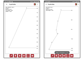 LTI Face Profiler for Android
LTI’s Face Profiler app combined with a professional TruPulse or Impulse laser range finder creates a complete profiling system designed to help maximize safety, manage inventory, and control costs – for less money than any other laser profiling package on the market. Face Profiler runs on most Android smartphones or tablets and sports an intuitive workflow that makes it easy to quickly shoot a profile. Calculation adjustments can also be made on the spot through the interactive interface, allowing for more accurate numbers. The Face Profiler app allows you to review profile data in three different ways: Coordinate Table, Shot Table, or XY Map. A variety of report formats allows you to generate and export results to a computer for further analysis and charting and graphing.