Forest Technology Simplified


Popular Forestry Products at LandMark Spatial Solutions
MobileMap & InventoryManager
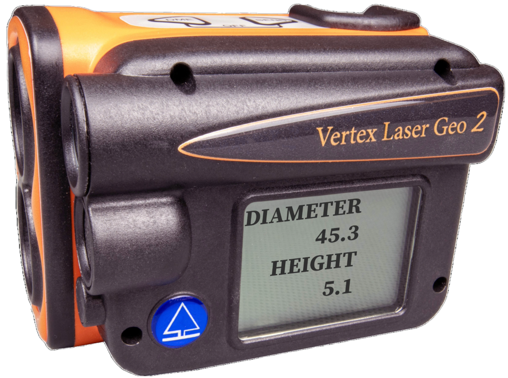
VL Geo 2 - with Remote Diameter
This device has all the features you have come to expect, but what makes this unique, is that you can record DBH or upper stem diameter or determine heights for a given diameter. An upgrade is now available to add the BAF function!

Juniper Systems Archer 4
The Archer 4 is a game changer for GPS and tree data collection. With and optional submeter/RTK add-on pod, this device will meet a wide variety of GPS needs. Available now!

Juniper Systems Spire
The Spire offers high-accuracy results out of the box. With optional RTK, this device is easy to use, lightweight, durable, and connects quickly to satellites. The Spire is designed and assembled in the USA!
Call us now for more information!
Expert advice from a friendly LandMark Spatial Solutions team member.
- Johnny Thompson – Sales
- Darian Yawn – Support
- Mark Books – Geospatial Solutions
- Claire Hillmeyer – Client Success
- Shane Mathews – Logging Solutions
Migrating to ArcGIS Pro for Foresters: Basic Short Course

Registration remains open through May 11, 2026, at 11:59 pm ET or until class capacity is full at 50 registrants. The course opens on May 5, 2026 at 10:00 am EST. This class is a collaboration with Society of American Foresters ForestEd and LandMark Spatial Solutions.
Featured Forest Technology Bestsellers

DJI Matrice 4E
This drone is great for fast mapping mission, inspections, video, and ortho image creation! With a 49 minute battery, built in laser range finder, new mid-range camera, and night scene mode, this drone will be a useful asset to any company.
Ez-Plot for ArcGIS Pro
Easily allocate plots across single or multiple polygons in ArcGIS Pro. Create grid layouts on an angle, apply buffers, and specify the number of plots per stand in the attribute table.

LTI 200i
The TruPulse® 200i laser rangefinder modernizes the original TruPulse® 200 with a streamlined intuitive interface and offers the user increased accuracy in measurements.

Juniper Systems Geode GNS3-H
Simple but durable the Geode has scalable accuracy options to met every project need. The Geode can get up to 1 cm accuracy. The Geode is designed and assembled in the USA!
Thank you for your interest in LandMark Spatial Solutions
We have developed industry-leading GPS and Forest Inventory solutions that are helping our clients MINIMIZE ERRORS and be more ACCURATE in their acreage, tree count, tree measurement, and timber volume estimations; be more EFFICIENT in the field and office; and achieve more PROFESSIONAL RESULTS at the end of the day.
LandMark Spatial Solutions Can Help You!
Please follow the links below or contact us if you need help or are interested in any of the following areas:
- GIS-based Forest Inventory Design and Analysis
- Using GPS under dense forest canopy to get accurate acres for procurement, site prep, and reforestation
- Using GPS to navigate to cruise plots
- Cruising more timber per day
- More accurate tree counts and heights on a plot
- Inputting cruise data more efficiently in the field
.
- Being more accurate and faster on volume calculations
- Creating professional maps more quickly
- Managing landholdings and inventories using ArcGIS
- Measuring and calculating volumes of chip piles and log decks
- A better way to enter, reconcile, and report Load Tickets and Scale information
- Using drones/UAVs for forest inspection and mapping
Questions? Want a demo? Call us now.
Schedule a demo or speak to a LandMark Spatial Solutions specialist.