 LTI TruPulse 360i

The TruPulse 360i fuses a tough, highly accurate, and intuitive next-generation rangefinder design with our patented TruVector 360° Compass Technology, enriching your laser measurements with azimuth data.
Take your measurements up a notch with TruVector 360° Compass Technology. The TruPulse 360i adds azimuth data to your measurements allowing efficient, single-shot positioning of remote features and 3D point-to-point calculations, a major advantage when completing projects that require accurate asset location and facility mapping.
This rugged unit is built to last with a lightweight and strong magnesium chassis and rubber-armored aluminum housing with a 100% waterproof rating.
- Slope distance
- Inclination (% slope) and azimuth
- Calculate horizontal & vertical distance
- Calculate height and missing line values
GPS Laser Offsets with the LaserSoft Connect App and ArcGIS Field Maps
With the free LaserSoft Connect App at their side, any user of ArcGIS® Field Maps app can measure laser offsets with a TruPulse® rangefinder. This exciting free app works with any brand of GPS/GNSS equipment, enabling users to acquire locations for those hard-to-reach features via point-and-shoot rangefinder workflows. Once you’re in Field Maps, just choose “Connect” as your offset provider, and you’ll be ready to tackle any mapping situation.
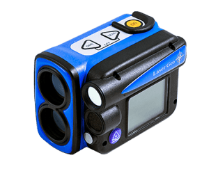 Haglof Laser Geo 2 – with remote diameter!
The Haglof Laser Geo 2 has unique capabilities that can measure height and DBH, map, process and store forest and field data. Long-range measurement with high precision laser, integrated tilt and compass sensors for accurate 3D measurements. Results are displayed on the integrated screen.
- Remote Diameter
- GPS & Compass
- Heights – 2 and 3 points
- Distance up to 2,000 feet
- Angle degrees and percent
- 3D pile application, perfect for log pile volumes
- Data storage – KML & CSV files
- Bluetooth
- Built-in Li-ion battery and USB charging
- IP67 Environmental rating
 Trimble TerraFlex
Trimble TerraFlex is a cloud-based solution that provides you with the tools to streamline your data collection workflows and delivers high accuracy positioning when you need it. With TerraFlex, your entire organization becomes more efficient.
- Fast, efficient, geospatial data collection across a fleet of mixed devices.
- Import and update existing data for up-to-the-minute information.
- Streamlined data management to keep your data organized.
- Direct integration with your Esri environment.