We are pleased to partner with Trimble Forestry to offer you a Free Seven Day Trial to Terrain Navigator Pro – the award-winning mapping software widely used by foresters throughout the U.S. Try it free today!
 Start mapping in minutes – TNP makes mapping easy!
Terrain Navigator Pro is a robust mapping platform combining built-in topographic maps and aerial photos with easy-to-use mapping tools.
- Includes topographic, aerial, satellite, and street maps of the United States – all accessible “off the grid”
- Add labels, marks, symbols, lines and routes to your maps
- Measure areas and distances
- Track colleagues and share data in near-real-time
- Save projects to the cloud
- Print professional quality, true-to-scale maps of any size
- Export/Import maps in popular formats
- Add private property lines, landowner names and parcel numbers*
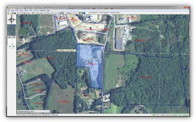
Private Land Ownership for TNP Desktop
Parcel Data on the Desktop
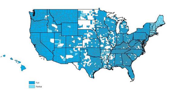
Terrain Navigator Pro now contains the option to show parcel boundaries on the desktop as part of a yearly parcel data subscription. The yearly parcel data subscription includes private land ownership details such as:
- Private land boundaries polygons
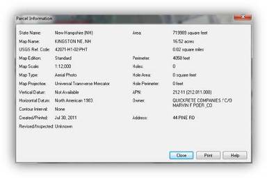
- The landowner’s name and address*
- Assessor’s parcel number (APN)
Primary features at a glance
- Find/Search Parcel
- Parcel to Track
- Parcel to Polygon
- Parcel to Route
- Parcel Centroid to Marker
- Send Parcel to GPS (as track)
- Send Parcel to GPS (as route)
- Send Parcel Centroid to GPS (as mark)
- Tracks, Routes, and Markers automatically sync to TNP mobile projects