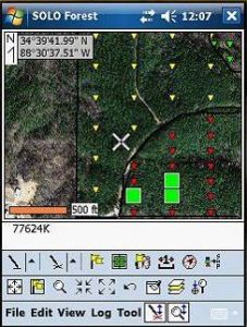
 Introduction to GPS using SOLO Forest
(7.5 CFE Contact Hours, Category 1)
Come learn how to use the Solo Forest GPS program to collect points, lines, and areas; use photos and topos in the field; create cruise grids; navigate to cruise plots; input survey data and navigate to corners; heads-up digitize in the field; export shapefiles; and make simple
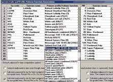 Introduction to TCruise Forest Inventory Field & Office
(7.5 CFE Contact Hours, Category 1)
Come learn how to set up and use the industry-leading TCruise program to collect and process your forest inventory data. We will also cover how to use the LandMark Reporting module and the patented Real-time Inventory GPS-based cruise system.
 Introduction to ArcGIS for Foresters
(11.5 CFE Contact Hours, Category 1)
The goal of this class is to simplify ArcGIS and make it a practical tool for the field forester. It is just the right blend of GIS terms, procedures, and forestry applications. We will cover the basics of ArcGIS, go into how to edit GPS data and then integrate it with basemaps to create terrific maps, learn how to digitize on top of aerial photos, create ArcGIS templates, and even go into georeferencing basemap layers. If you need to learn how to use this program for forestry applications, this is the class for you.